

On a 2016 visit with the Outdoor Writers Association of California to the Central Coast town of Morro Bay, the bounty of sea, dune, bay, and estuary ebb and flow against the sacred Nine Volcanic Sisters, the rocky Morros. Small town charm coexists with protected parkland and one of the few remaining functioning wetland estuaries in overpopulated California, a direct counterpoint to its channelized and endlessly pumped and polluted waterways. The landscape invites migrating birds and tourists, fosters endangered plants and animals, and allows fish populations to thrive.
Volcanic Peaks Over Saltmarsh and Dune
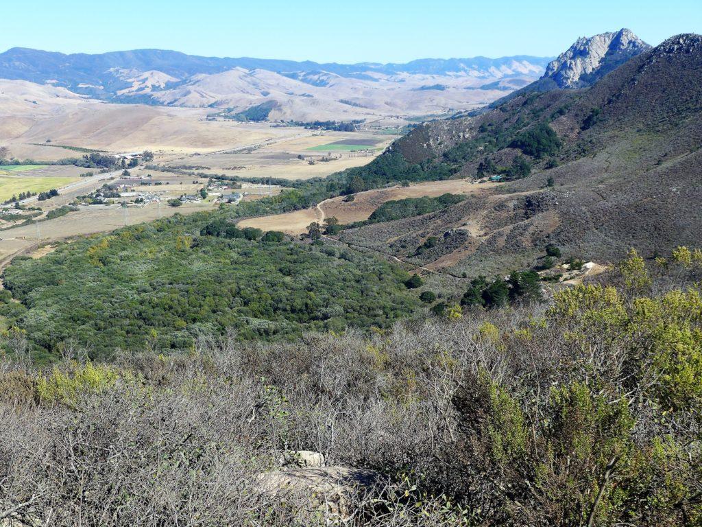
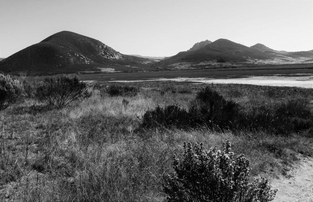
The Nine Sisters of San Luis Obispo County refer to the “volcanic plugs” that Franciscan Missionary Juan Crespi, a member of the 1769 Spanish Portolà expedition, called “Morros,” which means crown-shaped hill, reminiscent of the regal Moors who invaded Spain from North Africa. The ancient Morros rise up in a chain between San Luis Obispo and Morro Bay, formations of long-extinct volcanoes born 20 to 25 million years ago when magma hardened within a vent on an active eruption.
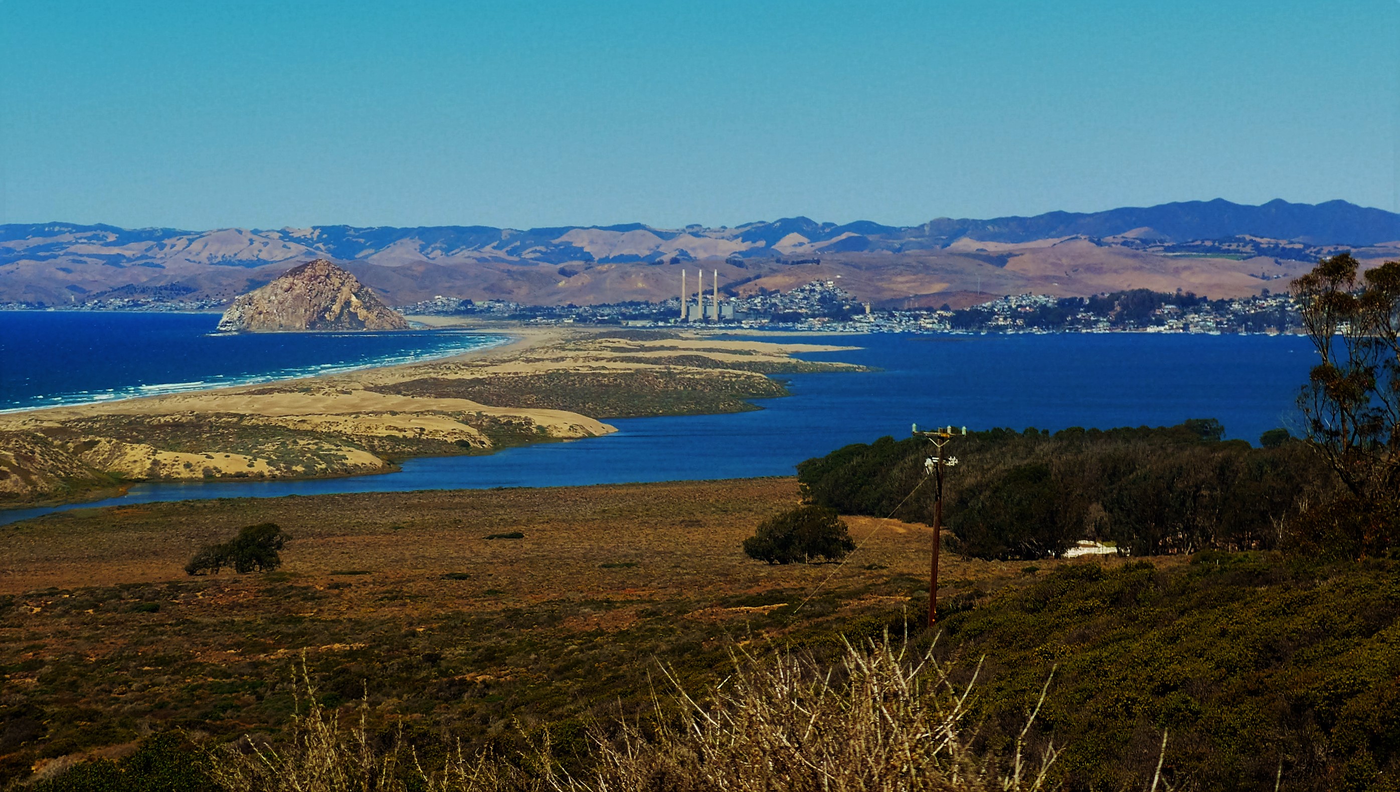
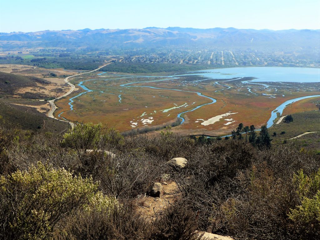
Yet, the physical feature that sets Morro Bay apart comes where the Sisters connect with the sea, the Morro Bay Estuary, where the watershed, a network of streams and creeks from 48,000 acres of land flows freshwater into the ocean’s salty tides. Morro Bay is one of the largest and least disturbed estuaries remaining in Central and Southern California. Its sheltered waters, mudflats, sand dunes, brackish salt marshes, and eelgrass beds provide rare and important habitat for a diverse array of fishes, birds, shellfish and other life. This, in addition to the recreational fishing, boating, kayaking, bird watching, and just plain relaxing to the sound of herons, cormorants, and owls squawking and hooting around the many rookeries.
A sea otter hugs an oyster shell looking up,
to the silhouetted curve of a great
white egret’s neck, as it collapses into
a eucalyptus nest releasing sustenance.
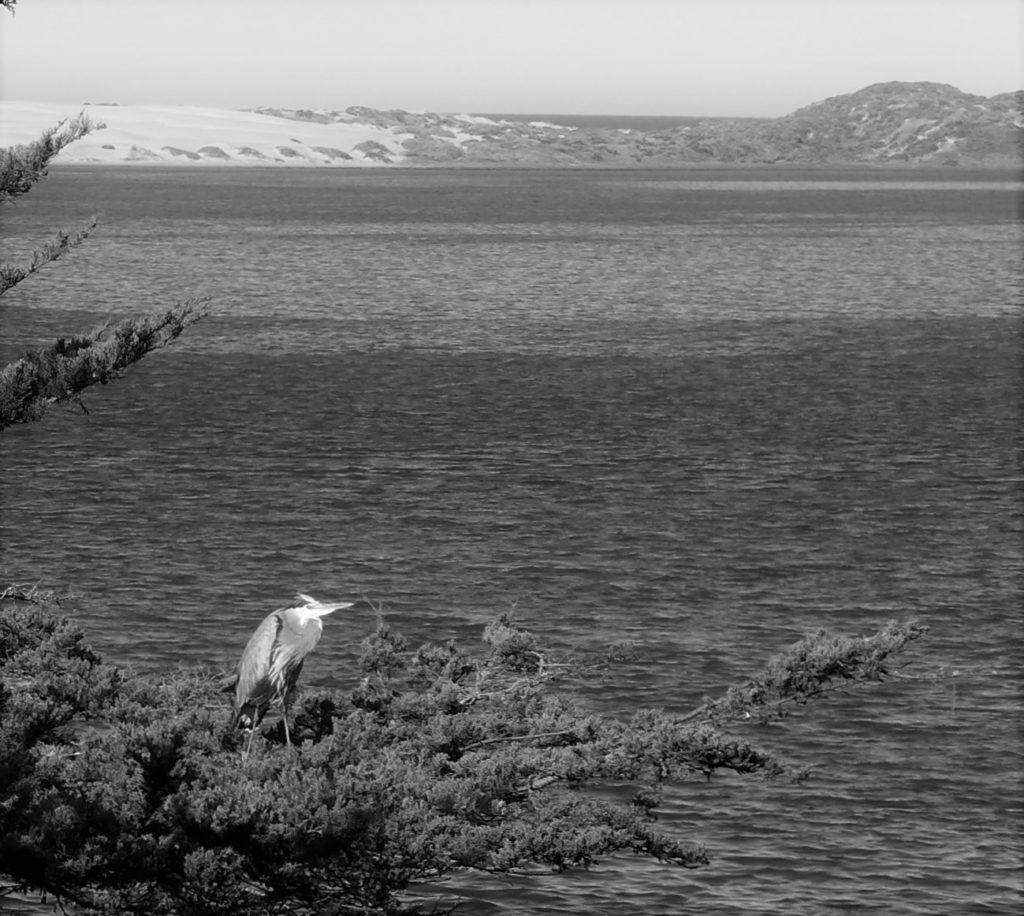
A great blue heron on a private piece of shore
is statuesque, still, and silent.
Moving on foot until the sharp beak
falls like a guillotine and spears a wayward smelt.
— Dawn Wood, Love in an Estuary
The combination of monumental and majestic Morros and living and breathing bay make Morro Bay a classically distinctive California coast landscape.
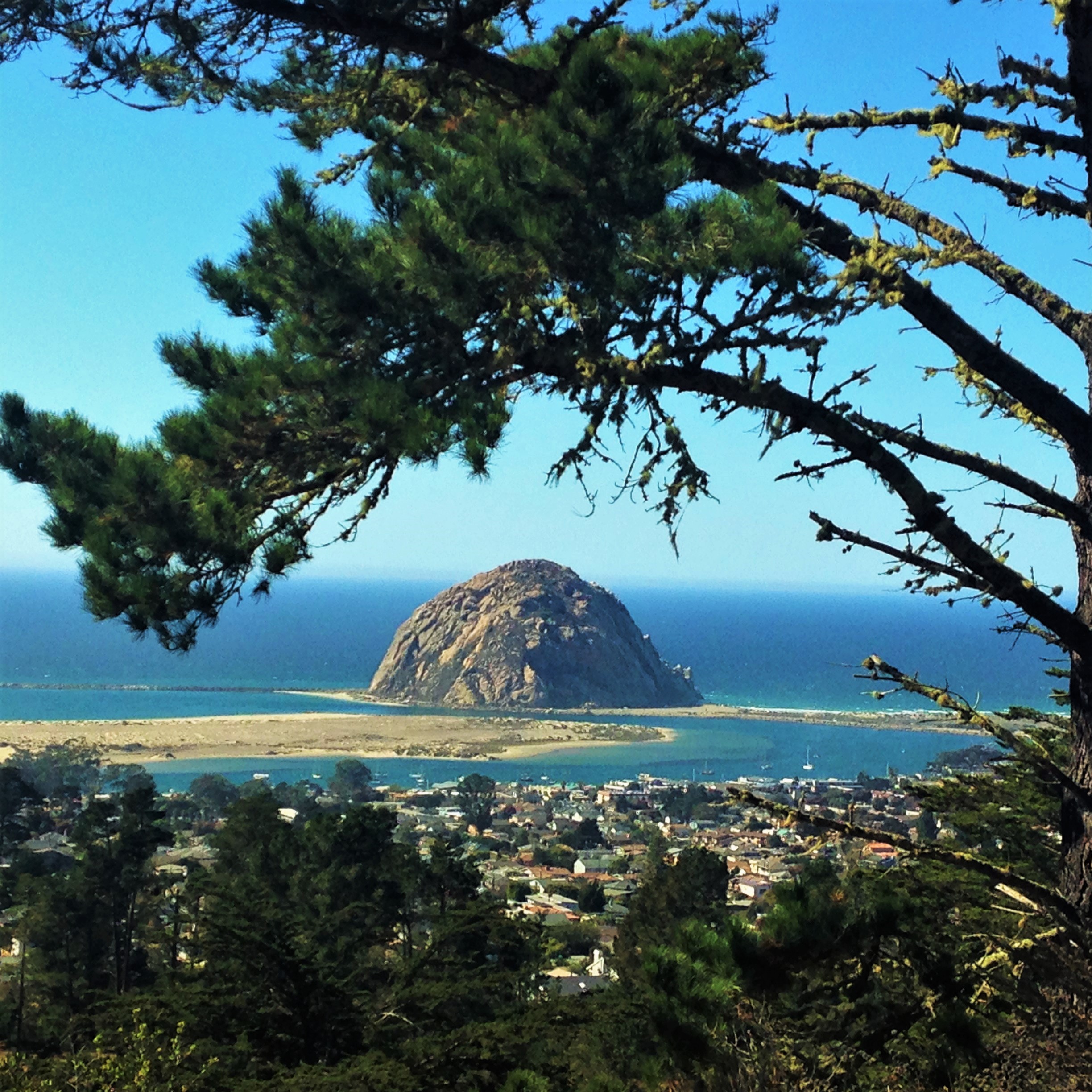
The Morros
The 576-foot Morro Rock, northernmost of the Sisters, heralds the entrance from the Pacific at Morro Bay. The site was considered sacred to both the Chumash and Salinian indigenous peoples. The Chumash Nation includes lands and Channel Islands to the south, all the way down to Malibu on the coast and as far east as the Tejon Pass. The Chumash had an important nearby prehistoric settlement at least as early as the Millingstone Horizon (6500-2000 B.C.E.), and the village was near the mouth of Morro Creek.
STORY: Eye of God: Big Bear’s Sacred Site of Creation
The Salinian Nation includes southern Monterey and northern San Luis Obispo counties with a 10,000 year old history. Sadly, both their heritage was decimated by the entry of Europeans who founded five missions on the lands of the Chumash and three on the lands of the Salinans. Today, the Salinan Nation descendants number just over 700 (Alger, 1).
According to Salinian legend, on Morro Rock Peregrine Falcon and Raven defeated the terrible two-headed serpent-monster Taliyekatapelta (Brusa, 55).
Falcon and Raven heard about the two headed black Snake (Taliyekatapelta) who ate People. They asked each other where their powers were located. Falcon’s power was at Me:neka and Raven’s was at Morro Rock. They decided to go see Snake, as he hid somewhere inland. On their way, the two-headed one ambushed them and began to chase Falcon and Raven. They flew away with Snake close behind, a black monster much more powerful than they had expected. Raven faltered and said he was going to cry. Falcon encouraged him to remember his power. They arrived at Morro Rock as Snake was winding himself around it. Falcon and Raven landed on top as Snake wound himself around and around the Rock. When Snake approached them, Falcon jumped and grabbed his cha’hal and killed Snake cutting him into four pieces.
— Yaxap’ (that’s all)
Version Edited by Jack Eidt, Based on variants told by Salinan descendant Eduardo Jose (Joe) Freeman and Betty War Brusa
 Expressions of Morro Rock’s magnetic and sacred power come from additional indigenous lore. On the winter solstice, when the sun was at its furthest point from the earth, the Salinans climbed it to pray for the sun to return. They hoped their prayers would ensure a full return of the sun and its warming rays. They also prayed for safe passage to the next world for loved ones that had passed on.
Both the Salinians and the Chumash have been granted permission to climb out onto the rock, protected as peregrine falcon habitat, to perform ceremonies on the summer and winter solstices. The Chumash have disputed without legal standing the Salinian right to that privilege, mostly as they don’t believe in actually climbing a sacred site.
The story of the peregrine falcon (Falco peregrinus anatum) is a compelling one. In 1970, due to humanity and its love for killing with pesticides like DDT and stealing the bird for pets, newspapers announced the peregrine as extinct west of the Rockies. Only 10 were left in California, with Morro Rock as one of the last breeding areas left. Captive breeding, the perennial last resort, undertaken by the Santa Cruz Predatory Bird Research Group, and intensive conservation efforts have helped the population survive, but threats remain.

The other Morros are Black Hill 665 feet, Cerro Cabrillo 911 feet, Hollister Peak 1404 feet, Cerro Romauldo 1,306 feet, Chumash Peak 1,257 feet, Bishop Peak 1,559 feet, Cerro San Luis 1,292 feet, and Islay Hill 775 feet.
The Grandeur of Morro Bay Estuary
At least one billion birds migrate along the Pacific Flyway each year. In winter, thousands make a much-needed stopover in Morro Bay, foraging for food on mudflats and resting on and near its clean waters in order to conserve energy for the continuation of their journeys. Where land and water meet, the wetlands of Morro Bay Estuary make this possible. Wetlands, one of the most productive ecosystems in the world, provide nursery habitat for juvenile fish species, and they sequester carbon where decomposing plants incorporate carbon into the soil.
I took an estuary tour this October with Biologist Claudia Freitas, a retired professor from Long Beach City College and Morro Bay Museum of Natural History docent. “If you come out here in the early morning this time of year, you can see 30 species of birds. This morning, we will see maybe twenty.” The estuary did not disappoint: We saw California thrasher, kingfisher, long-billed curlew, willets, least sandpiper, mergansers (fish-eating duck), black phoebe, white pelicans, marbled godwits, plovers, pied-billed grebes, great blue heron, turkey vulture, red-shouldered hawk, cormorants, Forster’s tern, elegant tern, and osprey.
STORY: Old Town Auburn, Portrait of a Gold Rush Town
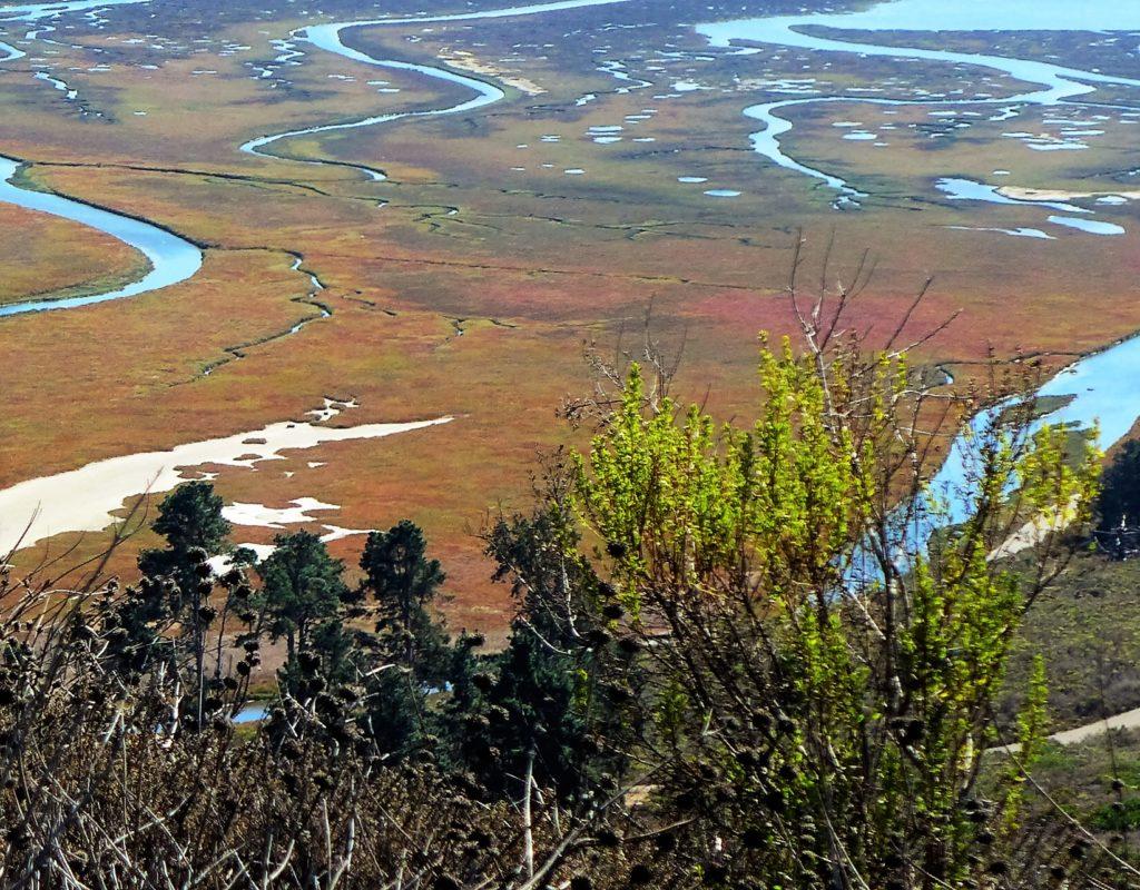 Bird populations are stable in the estuary and watershed, but scientists monitor the threatened Western Snowy Plover, who nests on the Sand Spit and Morro Stand State Beach. Because it nests directly in the sand, sand castle builders easily disturb its eggs. The Black Brant, a stocky goose who flies all the way to Alaska in the summer, feeds on the slowly disappearing eelgrass while hanging in the shoals on the bay. Eelgrass, an underwater flowering plant that cleans the water by slowing wave action and settling sediment, has experience a dramatic decline in Morro Bay. Though the exact causes of the decline are not yet known, drought, climate change, and wasting disease are possible factors.
The estuary is supported, protected, and restored by the Morro Bay National Estuary Program, one of three such designations in California, one of 28 in the US. I talked with Rachel Pass from the program and she explained that over 4,000 acres of sand dune and coastal scrub, grasslands and riparian habitats, as well as saltmarshes have been protected and over 400 acres have been restored or enhanced. She said the ongoing six-year drought has resulted in less water in creeks for steelhead to spawn, and less freshwater flowing into the estuary, which may affect salt marsh plants and eelgrass beds.
“Still,” Ms. Pass said, “the Morro Bay estuary is healthy overall and the Estuary Program is privileged to work with great partners to continue to protect and restore this vital resource.” The work done at Morro Bay stands as a towering example of protection and restoration. The program monitors conditions and the health of the creeks that feed into the bay, and also has overseen significant projects to restore biological integrity to vital environmental habitat.
 Monumental Morros ~ Living Estuary
 Monumental Morros ~ Living Estuary
Professor Freitas showed me proof in minuscule that Morro Bay Estuary thrives with biological life. The California horn snail (Cerithideopsis californica) positively own the tidal mudflats. Horn snails eat decaying plants and algae and benthic diatoms (a one-celled form of algae that lives at lower depths of the water), and their population health serves as an indicator for biologists. A link in the chain between parasitic worms called trematodes and shorebirds and waterfowl, as long as the snails thrive, birds also do.
The birdwatchers and students from local schools oohed and ahhed at the snails in the mud, the swirling grebes, cormorants roosting, and a dive-bombing red-shouldered hawk. The breeze blew soft, scented with eucalyptus and rotting saltmarsh. Another sweet day in Morro Bay.
Trip with the Outdoor Writers Association of California (OWAC), sponsored by the Morro Bay Tourism Bureau, and thanks to the Inn at Morro Bay, Windows on the Water, Morro Bay Museum of Natural History, Biologist Claudia Freitas, and AZHIAZIAM.
Sources
Brusa, Betty War. Salinan Indians of California and Their Neighbors. Happy Camp, CA: Naturegraph, 1975.
Dillon, Angela H. “Preserving Nature and Culture at Morro Rock.” Morro Bay, CA USA Guide to Nature, Recreation, Politics, Culture… Woodbury University, 18 Feb. 2008. Accessed 18 Oct. 2016. <http://morro-bay.com/morsels/dillon/>.
Felsman, Gary. “The Nine Sisters of San Luis Obispo County.” Sierra Club San Luis Obispo. Sierra Club, Santa Lucia Chapter. Accessed 18 Oct. 2016. <http://santalucia.com.s39011.gridserver.com/ninesis.html>.
Robinson, Pat, “Morro Rock, California,” Indigenous Religious Traditions, Colorado College, Accessed 18 Oct. 2016. <https://sites.coloradocollege.edu/indigenoustraditions/sacred-lands/morro-rock-ca/>
Updated 4 November 2016

Related posts:


Good afternoon, my name is Michele de Sá Vieira, I am an architect and I am currently developing a research on the Vulcanic Peaks of San Luis Obispo. I need two information:
. Know if the Davidson Seamount is public or private;
. What is the height of the (unnamed) vulcanic peak south of Islay Hill.
Thank you,
Michele