With the Enbridge Dakota Access, Kinder Morgan TransMountain, and Alberta Clipper-Enbridge Line 3 pipelines threatening to inundate the Earth with the dirtiest oil known to humanity, we survey a bird’s-eye view of the post-apocalyptic tar sands crude destruction sacrifice zones in Alberta, Canada, by photographer Alex MacLean.
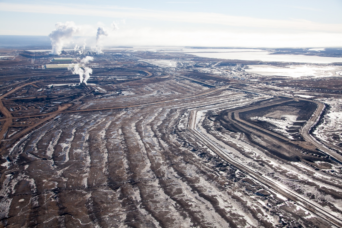
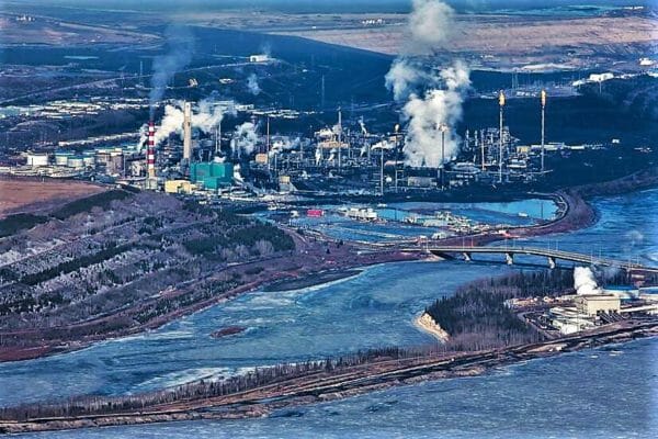
Steam and smoke rise from the Syncrude Mildred Lake mining facility in the Alberta Tar Sands. Photo By Alex MacLean.
PHOTOS: Famed Photographer Alex MacLean’s Photos of Canada’s Oilsands are Shocking
Alex MacLean is one of the US’s most famed and iconic aerial photographers. His perspective on human structures, from bodies sunbathing at the beach to complex, overlapping highway systems, always seems to hint at a larger symbolic meaning hidden in the mundane. By photographing from above, MacLean shows the sequences and patterns of human activity, including the scope of our impact on natural systems. His work reminds us of the law of proximity: the things closest to us are often the hardest to see.
In 2014 MacLean traveled to the Alberta oilsands, more properly referred to as tar sands, in western Canada. There, working with journalist Dan Grossman, MacLean used his unique eye to capture some astounding images of one of the world’s largest industrial projects. Their work, funded by the Pulitzer Center on Crisis Reporting, formed part of a larger report for GlobalPost.
DeSmog Canada caught up with MacLean to ask him about his experience photographing one of Canada’s most politicized resources and the source of the proposed Keystone XL and Northern Gateway pipelines.
“Looking at the pictures of the huge furnaces they have to use in the wells, you can see how much energy this takes to extract,” says photographer Alex MacLean. “If you’re driving around with this fuel, it’s 17% to 20% more carbon intense than regular gas.”
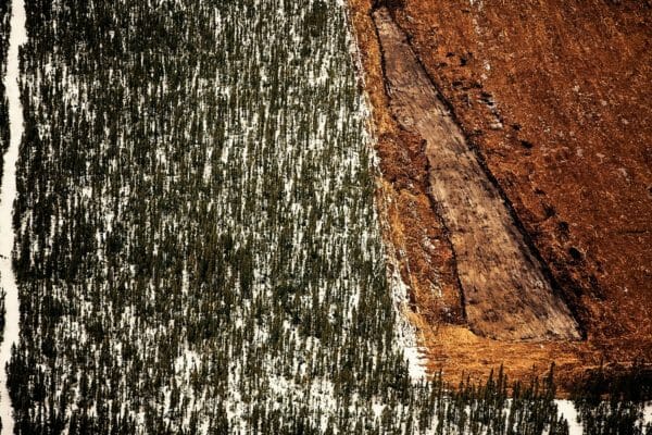
Forest removal for exploratory well pad. Shell Jackpine mining site, North of Fort McMurray, Canada.*
From the tar sands mine or drilling operation to the automobile gas tank, tar sands greenhouse gas emissions are 81 percent greater than those of conventional oil. — NRDC
DeSmog Canada: What was it like photographing the oilsands? Was it different from photographing other large-scale human spaces like highways or beaches?
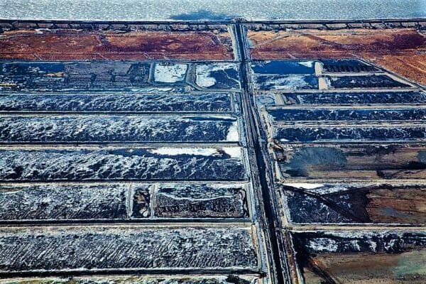
Beds leading up to tailing pond.
Alex MacLean: The oilsands covered a vast area of which I was only able to photograph part of. It was not only different from highways, beaches, etc., in that those are linear formations, but the scale of the oilsands area and the devastation to the landscape was overwhelming. I felt a relation between highways and the mines in that open pit mines and seismic exploration lines fragment the boreal forest just as highways do through urban areas.
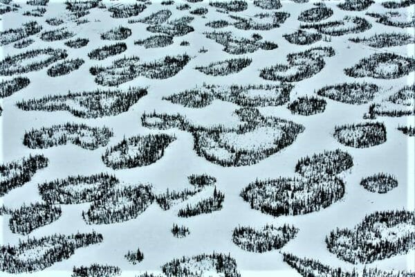
Patches of boreal forest intertwined with snow-covered muskeg, near McLelland Lake, Alberta, Canada.
The technology for removing bitumen from the tar sands is probably still best described as a work in progress. Where the feed lies closest to the surface, as, for example, at the Suncor site, the bitumen is strip-mined and then separated. But most of the tar sands lie too deep to be mined profitably. In these zones, a method known as in-situ extraction is used. In-situ extraction is based on much the same principle as Manley Natland’s scheme, minus the atom bombs. Typically, two horizontal wells are drilled into the sands, one above the other. High-pressure steam is injected into the top well; eventually, the tar sands grow hot enough—nearly four hundred degrees—that bitumen begins to flow into the bottom well. The technical name for this process is Steam Assisted Gravity Drainage, or SAGD. — Elizabeth Kolbert, The New Yorker
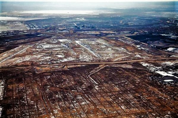
Clearing, dewatering, and seismic grid over the once boreal forest. Syncrude mining site, Alberta, Canada.
By 2022, it is projected that mining and in situ oilsands development will result in the daily clearing of 18.6 hectares of forest, or the equivalent of 34.5 football fields, every day. — Pembina Institute
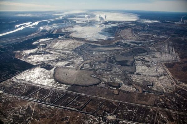
Syncrude Mildred Lake mining site. View south to upgrading facility with rising plumes of steam and smoke. Alberta, Canada.
Greenhouse gas emissions from oilsands production in 2022 are projected to be the equivalent to adding 22.6 million cars to the road in the U.S. — Pembina Institute
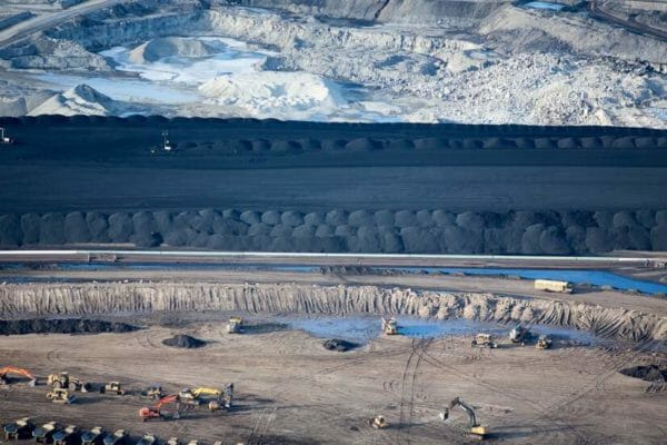
Suncor Oil Sands Project. Piles of uncovered petroleum coke, a byproduct of upgrading tar sands oil to synthetic crude. “Petcoke” is between 30-80 per cent more carbon intense than coal per unit of weight.
DsC: What led to your interest in the Alberta oilsands?
AM: I have been photographing around the issues of climate change since early on, and actually put out a book looking at land use patterns as they relate to energy and consumption in 2008 called “OVER: The American Landscape at the Tipping Point.” I was drawn to photographing the pipeline because I feel as though there is little public awareness that, if built, the Keystone XL will make avoiding catastrophic climate change much harder. The pipeline is an important link in a fossil-fuel production machine, stocked with bitumen deposits at one end and refineries at the other. The public is unaware that this oil production machine is poorly regulated, though it will cause serious environmental and health effects on local, regional and planetary scales.
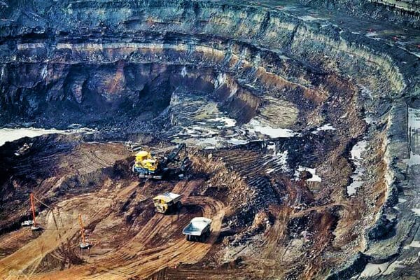
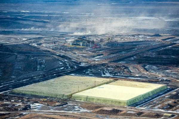
Mining operations at the North Steepbank Extension. Suncor mine, Alberta, Canada.
In a 2009 study commissioned by the governments of Alberta and Canada, scientists studied the incidences of cancer found in the tiny community of Fort Chipewyan. Fort Chip, as it is commonly known, has 1,100 residents and is located where the Athabasca River empties into Lake Athabasca, 124 miles north (downstream) of the major tar sands developments in Fort McMurray. In the report, scientists noted a diagnosed cancer rate from 1995 to 2006 that was 30 percent higher than what would typically be expected for that period of time. — NRDC
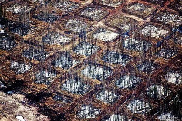
Checkerboard clearing of the “overburden” at Syncrude Aurora North mine site. Alberta, Canada.
Alberta’s Boreal forest is one of the last wild forests left in the world. It is home to thousands of plants and animals, contains 35% of Canada’s wetlands and, as a functioning whole, stores carbon, regulates climate and filters water. Approximately 23% of Alberta is affected by oil sands development – 50 times the area of the actual mining zone. An area the size of the state of Florida (149,000 km2) can be leased to oil sands development in the future. — Sierra Club Canada
Large quantities of diluted bitumen were spilled following pipeline ruptures in Marshall, Michigan, in 2010 and Mayflower, Arkansas in 2013. These spills, of at least 1.15 million gallons and 210,000 gallons, respectively, have proved extremely difficult to clean up. The tar sands oil that spilled in Michigan entered the Kalamazoo River, leading to the most expensive oil pipeline cleanup in U.S. history (now totaling more than $1 billion). After the spill in Michigan, the state Department of Public Health set up a broad surveillance effort that determined 320 people suffered adverse health effects, including cardiovascular, dermal, gastrointestinal, neurological, ocular, renal, and respiratory impacts. Similarly, following the Arkansas spill, air monitoring data showed significantly increased levels of benzene in the ambient air, and residents living close to the spill reported increased headaches, nausea, and respiratory problems. Despite these health concerns, the federal government has failed to promulgate guidelines for dealing with chemical exposure at oil spills and has not commissioned any studies regarding the long-term human health impacts of these spills. — NRDC
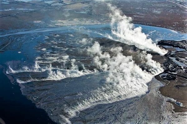
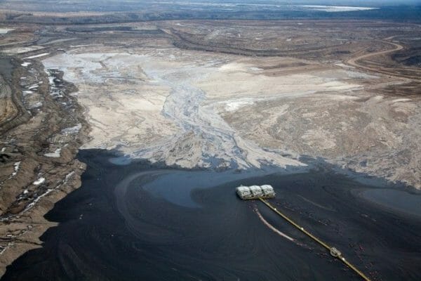
Smoke, steam, and gas flares rise from the Suncor upgrading facility. Reclamation efforts seen to the right, on what was once a tailing pond. Suncor has reclaimed only 7 per cent of their total land disturbance.
The Alberta tar sands require the construction of massive lakes of toxic sludge. A 2013 report concluded that an accident related to the failure of one of the tar sands destruction tailing ponds could have catastrophic impact in the aquatic ecosystem of the Mackenzie River Basin due to the size of these lakes and their proximity to the Athabasca River. Also, according to documents from the Canadian government, the tailings ponds are leaking into and contaminating Alberta groundwater. — DeSmogBlog
DsC: What is it like taking a bird’s eye view of humanity? Do you sometimes have great insights looking at civilization from such a removed, abstracted position?
AM: One of the interesting things about aerial photography is how so much of what you see about humanity is devoid of people. What I see is tracks and markings that are telling about our culture and values. When you see the destruction of landscapes, in this case of the boreal forest, with the obvious contamination of the environment via water and air pollution, you can’t help but feel that there is very short-sighted exploitation of natural resources that will have long-lasting environmental impacts.
Hot waste filling tailing pond. Suncor mining site, Alberta, Canada.
In 2009, new rules were released by Alberta’s energy regulator to help manage growing volumes of toxic tailings waste from oilsands mining. As of 2013, not a single company is complying with those rules. — Pembina Institute
Oilsands – tar sands – destruction and extraction consumes large amounts of water, despite current recycling efforts. In 2011, oilsands operators used approximately 170 million cubic meters (1.1 billion barrels) of water, equivalent to the residential water use of 1.7 million Canadians — or roughly the amount of water used by everyone living in Calgary and Edmonton combined. The Athabasca River is the primary source of fresh water for the industry, and oilsands mining uses three times as much fresh water as conventional oil production. — Pembina Institute
Growing pyramids of sulfur, a byproduct of upgrading bitumen. Mildred Lake, Alberta, Canada.
DsC: You’ve been photographing ‘human’ spaces for a long time. Have you noticed a change over the last few decades in your perspective as society has grown more aware of the ecological crisis and the scale of our impact?
AM: You can’t help but notice the growth that has taken place in the last thirty years, and the build-out of what was once natural spaces. I would say in the last 15 years, at an escalating rate, you begin to see more sustainable sources of energy through wind and solar farms, and reconfiguring of urban spaces to make them more walkable.
Overview of tailing pond at Suncor mining site.
When diluted tar sands crude oils arrive at U.S. refineries, they bear little similarity to conventional crude oils. Not only does the bitumen portion of the diluted mixture contain 102 times more copper, 11 times more nickel, and 5 times more lead than conventional crude oils, but the added diluting agent contains high concentrations of hazardous pollutants such as benzene. All of these chemicals may be released as air pollutants during the refining process. — NRDC
Surface oil on tailing pond. Suncor mine near Fort McMurray.
DilBit is a toxic petroleum slurry principally consisting of bitumen and hydrocarbons like benzene and naphtha. Benzene, naphtha and other hydrocarbons or natural gas condensates have been found to be carcinogenic. This has been understood as early as the 1950s. When heated to 158 degrees Fahrenheit, which results from the pipeline’s having to be pressurized to 1,440 psi, this slurry reveals another potentially dangerous quality: it easily becomes unstable. This resultant instability permits the liquefied hydrocarbons to return to gaseous form. When these “bubbles” implode shortly thereafter, explosive pressure spikes occur that embrittle and eventually rupture any gauge metal used for pipelines. — WilderUtopia
* All captions provided by Alex MacLean.
Image Credit: All photos copyright Alex MacLean. Used with permission.
Hello Jack Eldt,
How can we access high-res photo images for an educational film?
And what would it cost?
We’re looking for three or four images.
Thanks!
Transformative tales that thrive in the world of Lost Souls, Fallen Angels, Shapeshifters, Extra-Planetary Dragons, and Lucky Charms. From an assortment of writers, now available from Borda Books and WilderUtopia Books is The Fifth Fedora: An Anthology of Weird Noir & Stranger Tales curated by Jack Eidt and Silver Webb.


Pingback: Standing Rock is Everywhere: LA Unites Around Dakota Access | WilderUtopia.com
Pingback: Trump Approves Disastrous Keystone XL, the Blind Leading the Blind | WilderUtopia.com
Pingback: How Indigenous People Will End Oil Pipelines | WilderUtopia.com
Pingback: Tantoo Cardinal on Tar Sands: No Energy More Powerful than Natural Force
Pingback: How Indigenous People Will End Tar Sands Pipelines – EcoJustice Radio
Hello Jack Eldt,
How can we access high-res photo images for an educational film?
And what would it cost?
We’re looking for three or four images.
Thanks!
Here is Alex Maclean’s website: http://www.alexmaclean.com/contact/
Thanks for checking in!
Pingback: Generation Anthropocene: Altered Planet, Wild Literature - WilderUtopia